Earth Science worksheet
    Topic: Earth Rotation
    Earth Rotation
    1

    On June 21, an observer in New York State will see the Sun set

    (1) north of due east

    (2) north of due west

    (3) south of due east

    (4) south of due west

    2

    A high tide occurred at 6:00 a.m. at a beach on Long Island. The next high tide at this same beach would occur at approximately

    (1) 12:15 p.m. on the same day

    (2) 6:30 p.m. on the same day

    (3) 12:45 p.m. on the following day

    (4) 7:00 a.m. on the following day

    Base your answers to questions 3 on the time-exposure photograph shown below. The photograph was taken by aiming a camera at a portion of the night sky above a New York State location and leaving the camera’s shutter open for a period of time to record star trails.

    seasons-and-astronomy, earth-revolution, standard-1-math-and-science-inquery, geocentric-model-heliocentric-model, standard-6-interconnectedness, models fig: esci12012-examw_g34.png

    3

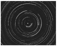
    During the time exposure of the photograph, the stars appear to have moved through an arc of 120°. How many hours did this time exposure take?

    (1) 5 h

    (2) 8 h

    (3) 12 h

    (4) 15 h

    4

    What causes many surface winds to deflect to the right in the Northern Hemisphere?

    (1) rotation of Earth on its axis

    (2) unequal heating of Earth’s surface

    (3) gravitational force of the Moon

    (4) gravitational force of the Sun

    5

    An observer on Earth measures the angle of sight between Venus and the setting Sun.

    seasons-and-astronomy, earth-rotation, maps-and-measurement, latitude-and-longitude, standard-1-math-and-science-inquery, velocity-slope-sediment-size-channel-shape-stream-valume-distance-from-the-sun-gravitational-force-period-of-revolution-speed-of-revolution fig: esci12013-exam_g1.png

    Which statement best describes and explains the apparent motion of Venus over the next few hours?

    (1) Venus will set 1 hour after the Sun because Earth rotates at 45° per hour.

    (2) Venus will set 2 hours after the Sun because Venus orbits Earth faster than the Sun orbits Earth.

    (3) Venus will set 3 hours after the Sun because Earth rotates at 15° per hour.

    (4) Venus will set 4 hours after the Sun because Venus orbits Earth slower than the Sun orbits Earth.

    6

    At a location in the Northern Hemisphere, a camera was placed outside at night with the lens pointing straight up. The shutter was left open for four hours, resulting in the star trails shown below.

    seasons-and-astronomy, earth-rotation, maps-and-measurement, latitude-and-longitude, standard-6-interconnectedness, models fig: esci12014-examw_g4.png

    At which latitude were these star trails observed?

    (1) 1° N

    (2) 30° N

    (3) 60° N

    (4) 90° N

    7

    The map below shows a portion of Earth’s system of latitude and longitude and five surface locations labeled A, B, C, D, and X.

    seasons-and-astronomy, earth-rotation, standard-6-interconnectedness, models fig: esci12014-examw_g9.png

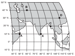
    It is solar noon at location X. At which location will solar noon next occur?

    (1) A

    (2) B

    (3) C

    (4) D

    Base your answers to questions 8 on the diagram below and on your knowledge of Earth science. The diagram represents Earth’s revolution around the Sun. Points A, B, C, and D represent Earth’s positions in its orbit on the first day of each of the four seasons. The major axis and the foci (the center of the Sun and the other focus) of Earth’s orbit are shown.

    reference-tables, solar-system-data, seasons-and-astronomy, motion-of-objects-in-the-solar-system, standard-1-math-and-science-inquery, eccentricity-rate-gradient-standard-error, standard-1-math-and-science-inquery, geocentric-model-heliocentric-model, standard-1-math-and-science-inquery, changing-length-of-a-shadow-based-on-the-motion-of-the-sun, standard-6-interconnectedness, models fig: esci12015-examw_g36.png

    8

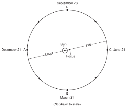
    At which two positions will an observer in New York State experience approximately 12 hours of daylight during one rotation of Earth?

    (1) A and B

    (2) A and C

    (3) B and C

    (4) B and D

    9

    When it is solar noon at a location at 75° W longitude, what is the solar time at a location at 120° W longitude?

    (1) 9 a.m.

    (2) 12 noon

    (3) 3 p.m.

    (4) 12 midnight

    Base your answers to questions 10 on the diagram below and on your knowledge of Earth science. The diagram represents the lines of latitude and longitude on Earth. Points A through E represent locations on Earth.

    seasons-and-astronomy, earth-rotation, standard-1-math-and-science-inquery, geocentric-model-heliocentric-model, standard-6-interconnectedness, models fig: esci12020-examw_g23.png

    10

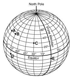
    Which two locations have the same solar time?

    (1) A and B

    (2) B and D

    (3) C and E

    (4) D and E

    Base your answers to questions 11 on the calendar below, on the diagram in image provided, and on your knowledge of Earth science. The calendar shows the phases of the Moon for January 2019 as viewed by an observer in New York State. Some phases have been labeled. The diagram on your answer sheet represents eight positions of the Moon in its orbit around Earth.

    seasons-and-astronomy, motion-of-objects-in-the-solar-system, standard-6-interconnectedness, models, standard-6-interconnectedness, patterns-of-change fig: esci-v202-exam_g48.png

    11

    On the diagram in the image provided, place an X on each of the two positions of the Moon in its orbit where neap tides (the smallest difference in the water levels between high tide and low tide) occur. [1]

    Allow 1 credit if the centers of only two Xs are placed on the diagram – one to indicate the 1st quarter phase and one to indicate the 3rd quarter phase, as shown below.

    seasons-and-astronomy, earth-rotation, seasons-and-astronomy, motion-of-objects-in-the-solar-system, standard-6-interconnectedness, models fig: esci-v202-rg_g3.png

    Base your answers to questions 12 on the map below and on your knowledge of Earth science. The map shows the four time zones across the continental United States. Eight cities are labeled on the map.

    seasons-and-astronomy, earth-rotation, standard-1-math-and-science-inquery, velocity-slope-sediment-size-channel-shape-stream-valume-distance-from-the-sun-gravitational-force-period-of-revolution-speed-of-revolution, standard-6-interconnectedness, models, standard-6-interconnectedness, patterns-of-change fig: esci-v202-exam_g50.png

    12

    State the time at San Francisco, California, when it is 12 noon at New Orleans, Louisiana. Indicate a.m. or p.m. in your answer. [1]

    Allow 1 credit. Acceptable responses include, but are not limited to:

    • — 10:00 a.m.

    • — 10 am

    • — 1000 (military time)

    • — 10 in the morning

    Base your answers to questions 13 on the diagram in image provided and on your knowledge of Earth science. The diagram is a model of the sky (celestial sphere) for an observer at 50° N latitude. The Sun’s apparent path on June 21 is shown. Point A is a position along the Sun’s apparent path. Angular distances above the horizon are indicated.
    13

    The Sun travels 45° in its apparent path between the noon position and point A. Identify the time when the Sun is at point A. Include a.m. or p.m. with your answer. [1]

    Allow 1 credit for 3 p.m. or 3:00 p.m.

    • Note: Allow credit if the “p.m.” lacks periods.

    Base your answers to questions 14 on the data table below, which shows the length of a shadow, in centimeters, made by an object at different times during the day in New York State.

    seasons-and-astronomy, earth-rotation, standard-1-math-and-science-inquery, velocity-slope-sediment-size-channel-shape-stream-valume-distance-from-the-sun-gravitational-force-period-of-revolution-speed-of-revolution fig: esci12016-examw_g46.png

    14

    Predict the length of the object’s shadow at 2:30 p.m. [1]

    cm

    Allow 1 credit for any value from 130 cm to 160 cm.

    Base your answers to questions 15 on the diagram below and on your knowledge of Earth science. The diagram represents a view of Earth from above the North Pole, showing longitude lines at 15 degree intervals. Letters A and B represent surface locations on the equator.

    seasons-and-astronomy, earth-revolution, seasons-and-astronomy, seasons, standard-1-math-and-science-inquery, geocentric-model-heliocentric-model, standard-6-interconnectedness, models fig: esci12017-examw_g29.png

    15

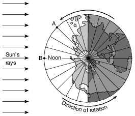
    State the time at location A when it is noon at location B. Indicate a.m. or p.m. in your answer. [1]

    Allow 1 credit for a response that indicates a time value of 9 a.m. Acceptable responses include, but are not limited to:

    • — 9:00 a.m.

    • — 9 o’clock in the morning

    • — 0900